Experience from the previous expeditionThe main lessons of the March 2006 expedition were that firstly, it was a revelation just how accurate a DR position could be simply by keeping track of distance travelled, using the odometer; and heading, using a magnetic compass. The main problem in using a magnetic compass inside a vehicle is the compass deviation caused by the metal mass of the vehicle, so for this trip I made a hand held sun compass, which could be used either as a principal means of determining heading or - more conveniently - to correct the magnetic compass heading for deviation.
Secondly, the heat of the desert appeared to play havoc with the index error of the sextant. A strategy was adopted whereby sightings were taken of four object at the Cardinal points. This had the effect of cancelling any systematic errors, of which index error would be the main contributor. This appeared to greatly increase the reliability of the sights. Subsequent to the March 2006 trip, I learnt that Royal Air Force navigators using bubble sextants adopted exactly the same strategy. Too, Ralph Bagnold in his early exploration of the Western Desert used a theodolite to fix his position (see Appendix I of "Journeys in the Libyan Desert 1929 and 1930", by Bagnold R.A., Royal Geographical Society, Vol. 78, 1931, pages 522-535) according to the methods outlined in volume one of "Hints to Travellers", ninth edition, published by the Royal Geographical Society in 1906. The methods advocated in "Hints" was exactly the same as I had finally been forced to adopt - sightings on stars as near as possible to the Cardinal points.
The sextant I took with me on this trip was a Link A12, but not the same instrument I had taken with me the previous year. This instrument had been 'won' on ebay in a rather neglected state and subsequently rebuilt, replacing the bubble observation mirror and fixing a number of other ailments. In trials through the year I had reduced the size of the bubble to about half what I had used previously, which seemed to give an improvement in accuracy of measured altitudes. This instrument was thus better set up that the one I had used on the previous trip. I measured an index error of about -5' at Riccarton when using the sextant, but from experience in March 2006 I did not expect this the remain valid. I was not disappointed!
Main celestial navigation results
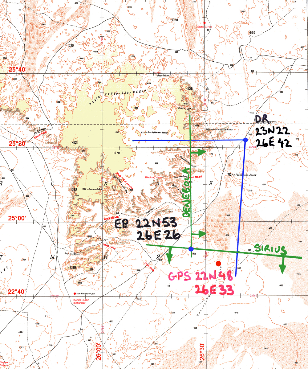
The first attempt at a position fix for a campsite was on the 11th of March 2007. It was our first camp after entering the desert and was located at the Eastern approaches to the Southern tip of the Gilf Kebir. It was a windy night and I did only the minimum to get a fix. As before, azimuths are in blue, position lines in green. Polaris was not available, due to the barchan dune to the North we were using as shelter for the camp. So I did a sighting on Sirius to the South and Denebola to the East. An index error of -5' was used in reducing the sights. First thing to note is that the estimated position was a long way North of the fix! The second thing to note is that the altitudes are both significantly lower than they should be - a change in index error?
Interestingly, I also had my aneroid altimeter along, which gave an altitude for this campsite of 640m. The celestial fix was for a position whose altitude was indicated to be almost 800m. A possible ploy could have been to assume the true position was equidistant from both position lines, either "towards" or "away" from both objects and at a position with altitude 640m. Only the "towards" direction was possible as the "away" direction headed uphill towards the Gilf. Moving the position of the fix in this way would have put it within 3' or so of the actual position.
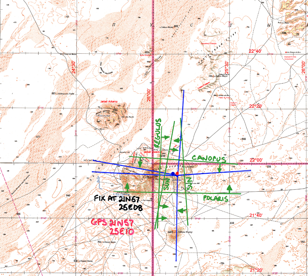
The next day, we continued our journey to our campsite for the next week, which would be in Karkur Talh, which is the wadi complex in the North East of Jebel Uweinat. Sightings on Canopus, Regulus and the sun were quickly obtained, but I needed Polaris to the North to get my "box" sighting. Strong winds during the previous days had blown a lot of dust into the atmosphere and Polaris was hardly visible, defying attempts to obtain an altitude for several days. Finally, however, an altitude for Polaris was obtained - but for some reason I had difficultly in getting consistent results and a large number of sights had to be averaged to get a final altitude of any precision. So, on the 14th of March, I was able to plot the position lines for a fix on this campsite.
As can be seen, a rather nice box is formed by the position lines from the various sightings for bodies in the Cardinal points. The box has side length of about 10', indicating an unaccounted for index error of some 5'. All position lines are "away" from the body concerned, so the sightings are too low and the error is therefore -5'. I could now confirm that the index error had changed and was now -10' instead of the -5' that it had been at Riccarton. The final fix is just 2' to the West of the GPS position. (As on the previous trip, the GPS was only consulted once the fix had been made using traditional celestial navigation.)
It was rather pleasing that the method of using sightings on four bodies at the Cardinal points was working as hoped.
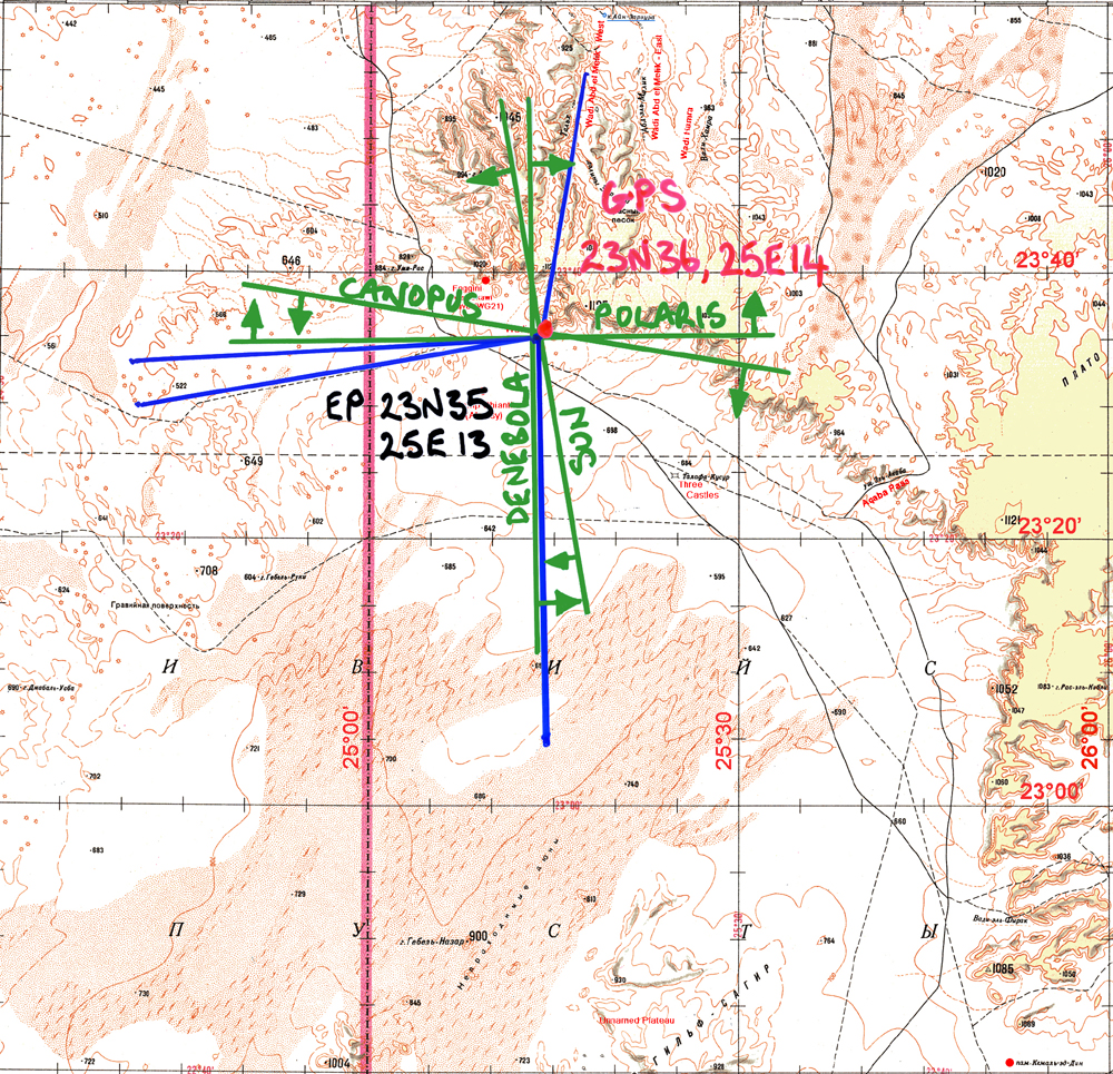
Some days later, at the Wadi Sora campsite next to the "Cave of Swimmers", made famous in the film "The English Patient", I took a number of further sightings using the index error of -10'. The result was a really excellent set of results with a celestial fix only 1' away from the GPS position. This is really the best that can be hoped for using the A12 bubble sextant, which has a precision of only 2' on the vernier - though, of course, it is more accurate than that.
A few weeks after returning to Riccarton I did a series of sun sights with the sextant, which showed that the index error had now returned to -5', just what it had been before setting out for the Sahara.
The sun compass
Another innovation for this trip was the fabrication of a sun compass. This consisted of a wooden handle into which was set a small telescopic aerial to act as a gnomon. A wheel with azimuth headings inscribed on its rim and shadow lines for each hour of the day inscribed on its top.
The idea was to hold the compass so that the handle was vertical and rotate it so that the sun's shadow fell at the shadow line appropriate for the time of day (as obtained from a watch - the shadow lines were set for local time). With the eye behind the gnomon, lining it up on the object whose bearing was required, the bearing was read off from the edge of the wheel closest to the observer.
The main use was inside a car, where the steel of the vehicle would influence a magnetic compass. (Outside the car, the magnetic compass was much more convenient and magnetic deviation was negligible). The sun compass proved quite useful, particularly in the drive up to the LDG area, where the magnetic compass was shown to be reading about 20° too far West. (Magnetic compass said heading was 10° whereas sun compass said 30°.) The DR position after a long driving spell was exactly the same as the GPS position. This was a very simple sun compass in that the shadow line card for the top of the wheel was created specifically for the location, time of year and the local time in the Western Desert. The card was just stuck on with double sided sticky tape to be easily removable.