The first European reference to Zerzura is in an 1835 account by the English Egyptologist John Gardner Wilkinson. His account was based on a report by an Arab who said he found the oasis while searching for a lost camel. Wilkinson placed the Oasis five days West of the track connecting the oases of Farafra and Bahariya. "The Oasis called Wadee Zerzoora" abounded "in palms, with springs, and some ruins of uncertain date." Tales of lost desert locales found by searchers for stray camels were common, but Wilkinson's account was given credence when a number of oases described in the account were found by later explorers. Zerzura itself proved elusive, however. Wilkinson associated Zerzura with three fertile valleys and this would finally lead to the discovery of the lost oasis of Zerzura.
The story starts in 1909 when W.J. Harding King made the first of several journeys along an old trade road that ran Southwest from Dakhla. He had seen a flight of small birds enter Dakhla from the Southwest and finding freshly eaten olives in their stomach, reasoned that he would find a lost "olive" oasis Southwest of Dakhla. Harding King ventured 320 km along the old road, but found no abandoned desert city.
Six years later, John Ball, director of the Egypt Survey Department, set off from Dakhla in an attempt to find the lost oasis. He travelled 320km West of Dakhla by car, rounding the Southeast extremity of the Great Sand Sea. But no oasis was found.
Between 1924 and 1926, the major features of the Western desert were put on the map due to the efforts of two extraordinary men. Oxford educated Ahmed Mohamed Hassanein Bey set out from Kufra oasis by camel and came upon Arkenu and Uweinat, two legendary mountainous regions rising "like mediaeval castles" out of the desert sand, and surveyed them accurately for the first time. Another Egyptian, Prince Kemal el Din - a man whose pockets were as deep as his mind was active - commissioned a number of tracked vehicles from Citroen, the French car manufacturer. He put the Gilf Kebir, an area the size of Switzerland, on the map.
With the Western Sahara being breached and finally giving up its secrets, the debate about the location of Zerzura reached fever pitch. Variously, it was thought to be within the Great Sand Sea, West of the Selima oasis and Harding King clung to the idea of a rain fed "olive" oasis. Notably though, the Hungarian explorer Lazlo Alamasy believed it would found in the area of the Gilf Kebir.
Meanwhile, great advances were being made in the technology of desert travel. Led by Ralph Bagnold, an enterprising group of English officers modified the lightweight Model A Ford for desert running. They developed "sand ladders" made of wire and bamboo and combined with lowered tyre pressures, found they were able to negotiate soft sand and run over dunes. They developed a system for conserving radiator water, which enormously extended the potential range of expeditions. These improvements gave a mobility unattainable with the heavy, slow, tracked Citroens and opened the Great Sand Sea to further exploration. Also, it was not long before light aircraft began to be used in conjunction with expeditions on the ground.
Ralph Bagnold had a single mindedness in persuit of his goals that resulted in a number of successful epic journeys through the desert during the early 1930's. During WWII Bagnold set up the Long Range Desert Group, a highly mobile special forces unit which would use the methods he had pioneered in exploring the desert to get behind the enemy lines and attack strategic targets. Bagnold's physical toughness was matched by a mind of high calibre. After the war, he wrote a number of books on his journeys and produced a seminal work, "The Physics of Blown Sand and Desert Dunes", for which he was elected to the Royal Society.
It was Lazlo Almasy, however, who would finally scoop the prize of finding Zerzura. Almasy had a precocious interest in the fast developing technology of modern transport. By the age of ten, Almasy was driving his father's Oldsmobile car. He attended an English boarding school and at the age of 17, attained his private pilots licence. As a pioneer in the early days of aviation, Almasy became one of the best pilots in the Hungarian airforce. Almasy recieved the title of Count from a grateful king, Karl IV, for whom he acted as driver during the king's ill fated attempt to restore the Hungarian throne after the collapse of the Austro-Hungarian monarchy.
So it was that in 1926, Count Ladislas (Lazlo) de Almasy went to Egypt as a representative of the Steyr Automobilwerke car manufacturer. A driver of great skill, Almasy took part in a number of long drives in the late 1920's which were part test drive, part safari. In 1929, he journeyed across East Africa, the Sudan and Egypt. This 12,000km trek was to become the turning point in his life when he rediscovered the infamous caravan path, the "Darb el Arbain" or Road of Forty. This had been the ancient slave route by which hundreds of thousands of slaves had been brought up from Africa into Egypt. The journey took 40 days, travelling from well to well. The route is marked by the bones of humans and camels for whom the journey was too much, too far.
It was on this trip too that Almasy fell in love with the immense wasteland of the Sahara desert. Hearing the legend of fabulous lost oasis of Zerzura, Almasy determined to find it. After examining all the rumours, legends, maps and historical documents, Almasy determined that Zerzura would be found in the the only part of the desert that remained unexplored - the Gilf Kebir region. Almasy never had the necessary funds to finance such a journey of exploration himself and was dependent on interested-but-rich fellow enthusiasts in the Zerzura quest to bankroll the expeditions.
 His first unsuccessful attempts were financed by Prince Kemal el Din, who had discovered the Gilf Kebir in 1926, and a young English baronet Sir Robert Clayton East-Clayton. In 1932, Robert Clayton East-Clayton, Count Almasy, Colonel Patrick Clayton of the Egypt Survey Department (no relation to Sir Robert) and Wing Commander H.W.G.J. Penderel flew over the Gilf Kebir and made a sighting of two green valleys. They followed this up with an attempt to reach the valleys overland, but ran short of petrol.
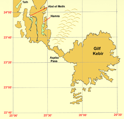
The sighting of the valleys caused a sensation, but Almasy's attempts to return to the Gilf Kebir were frustrated when his patrons, Sir Robert and Prince Kemel, both died within months of each other. However, in 1933, two separate expeditions returned to the Gilf Kebir. The first was that of Pat Clayton and Lady Dorothy Clayton, the widow of Sir Robert, which located the two green valleys. Almasy and Penderel arrived shortly afterwards, having been given directions by an old Tebu caravan guide, Ibrahim Abd al-Melik. Ibrahim also told them of a second valley, Wadi Talh, the "Valley of the Acacia". On May 3rd 1933, Almasy and Penderel entered the valley that was then named for Ibrahim Abd el Melik, "Servant of the King".
They found a long valley, with lots of acacias and sites of Tebu camps with grass huts and baskets. On May 5th, Almasy found a the valley which is now known as Wadi Talh - though as Ibrahim was not present as a guide, it is now difficult to be sure that the valley Almasy found was the valley Ibrahim meant.
Almasy and Penderel then headed South for Jebel Uweinat, finding a way through the Gilf Kebir escarpment via what they named the Aqaba (Difficult) Pass. At Uweinat, they met up again with Ibrahim. It was now that the old Tebu finally gave up the information that there was indeed a third valley, Wadi Hamra or the "Red Valley" due to the red sand in the valley. At last, Almasy had the three green valleys of the Zerzura legend. Zerzura had been found.
It turned out that the wadis that the Clayton expedition had located were Wadi Abd el Melik and Wadi Hamra. By common consent today, the three wadis associated with Zerzura are Talh, Abd el Melik and Hamra. But this actually makes four green valleys, as Wadi Abd el Melik has two arms, now called Wadi Abd el Melik East and West. It could be argued that from a camel herders point of view, the three valleys of Talh, with Abd el Melik East and West, form a natural group as Hamra is a couple of days journey away on the other side of the plateau.
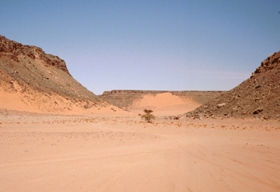
 This photo shows Wadi Hamra as it is today. It is evident from the line of acacia trees and scrub vegetation that deep underground, water still runs though this valley. But the sand has claimed this land. Now, the wandering Barbary sheep and desert fox have the wadis to themselves.
Count Lazlo Almasy's exploits were popularised by the 1996 Oscar winning film, "The English Patient", taken from Michael Ondaatje's book of the same name.
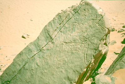
 No ruins of any lost city were ever found. It would seem likely that the fabled riches of the lost city of Zerzura became entangled and combined with the fable of three green valleys with good pasture - a prize worth just as much to an Arab camel herder. Today, the area is famous for its rock art, principally rock engravings, some of which are over 5,500 years old. This photo shows a typical rock engraving, picked out on a suitably flat rock surface. The large animal is a cow. To the left (behind the cow) is a giraffe and another cow. Above the cow is a deer. As an area becomes more arid, giraffe and elephant are the most tolerant of arid conditions and so the last to remain.
It is interesting to speculate why the old Tebu, Ibrahim, had been so reticent about telling Almasy the location of the three green valleys. Probably because he had used the valleys as grazing for his camels and he wanted to keep their location a secret. But by that time, the valleys were drying up and were no longer viable for grazing, so Ibrahim reasoned that the inducement which Almasy doubtlessly offered was sufficient recompense for revealing the location of grazing pasture for which he no longer had any use.